The Maiden of the Rock: A Deep Dive into Xunantunich Mayan Ruins in Belize

Image
The Maiden of the Rock: A Deep Dive into Xunantunich Mayan Ruins in Belize Belize is a land rich with history and adventure, and for those who love to explore, its ancient Mayan ruins offer a glimpse into a world both magnificent and mysterious. My wife, Linda, and our friends, Eamon and Athena, and I dedicated our third day in Belize to exploring one of the most magnificent of these sites: Xunantunich, or "The Maiden of the Rock." This post will serve as your comprehensive guide to this breathtaking archaeological site, sharing our firsthand experience and helping you prepare for your own unforgettable journey. The grounds are well-kept, which we noticed the moment we walked into the central plaza, and the site is much bigger than we anticipated. The Journey Begins with a Hand-Cranked Ferry Getting to Xunantunich is a part of the adventure in itself, and it’s a detail that adds to the site's remote and timeless feel. The day of our visit was incredibly sunny, and the dri...
Trip Report: Big Bend Round 2

Preparing for the 100-mile Extended Mountain Loop

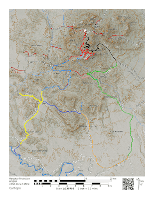
It’s been a while, but I finally found the time to make it back out to Big Bend National Park. If you are interested in our first trip to Big Bend, you can follow along here: Big Bend 2015. I headed out for the trip around 2 pm on December 2, 2018, for what I’ve termed the Extended Outer Mountain Loop, a 100-mile backpacking trip spanning 7 days. The plan was to meet up with my dad, Bmo, in the Chisos Mountains, cache water, and then start the adventure.


100 Mile Loop
Planned 7-day route for Big Bend National Park

Big Bend National Park Background

Location: 310, Alsate Dr, Big Bend National Park, TX 79834
Admission: $25 per vehicle, $14 campsites, $12 backcountry pass
Elevation: 1,800 to 7,832 ft.
Weather: Varied from rainy, cloudy, and sunny, 30 to 65°F
Difficulty: Strenuous


My 7-days worth of food
7 days' worth of food


The Drive Out

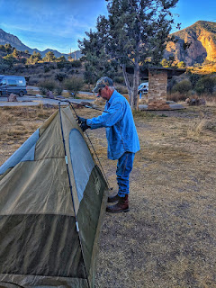
I didn't get to leave as early as I would have liked because I needed to finish up some work, and once on the road, I made a quick stop in Comfort to grab some water for caching. After that, it was almost six hours of driving, and by the time I arrived in West Texas, it was extremely dark. Thankfully, I didn't have any run-ins with wildlife. I quickly found Bmo in the Chisos Basin and his primo campsite. It was pretty chilly when I arrived, and we walked for a bit as I set up my tent. Because it was cold, late, and dark, we headed to bed pretty quickly after I arrived. This was also the first real night in my UGQ quilt, and it worked perfectly.


setting up a tent in the chisos basin campgrounds
BMO is setting up his tent in our new campsite.


Water Caching

We had a quick breakfast and decided to place the caches at the most challenging locations first, while there was still sunlight; however, we realized we'd spent the night in a stolen campsite, so we quickly found a new site for our base camp and moved. Finally, on the road, the first stop was at the Dodson Trailhead, located down Juniper Canyon Road. It was a rough and slow ride at times in our truck, but we made it just fine without four-wheel drive. After that, we headed out to the south end of Black Gap Road to cache at the Elephant Tusk Campsite. Black Gap is the most challenging and technical road in the park, but the southern section is passable with a high-clearance vehicle. We wanted to ensure we could make it before reserving the site, and we arrived at Elephant Tusk with a few scrapes to the truck's undercarriage.


early morning view from our campsite in the chisos basin
The view of the Chisos Mountains from our campsite


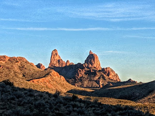
Finally, we headed back by the River Road to the main road to cache at Homer Wilson Ranch. We made a quick stop at the Panther Junction Ranger Station to obtain our backcountry passes for the next few days. At first, the ranger thought I was just some gung-ho kid, but I slowly explained my trip and how I would be supported by BMO, which calmed her down. With our passes in hand, we were back on the road heading towards Homer Wilson, which has a bear box just off the Dodson and Blue Creek Trail intersection. Our last stop of the day was Mule Ears Overlook. There is no cache site there, but you can cache water anywhere in Big Bend as long as you have a bear canister and pack everything out. So I left some water hidden on Mule Ears Trail.


Mule Ears from the Mules Ear overlook
The Mule Ears are in the distance from the Mule Ear Overlook.


Our last stop before heading back was the Sotol Vista Overlook, where we took in a terrific sunset. Returning to the basin, Bmo cooked an amazing dinner while I packed up my gear. I’d decided to sleep in my car, so I could have everything packed up, and I could roll out with no fuss. I am notoriously bad at breaking camp, and I wanted to hit the trail as early as possible.


Sunset from the Sotol Vista Overlook


Backpacking Day 1

The day of the big adventure! I woke up, had oatmeal and coffee for breakfast, woke Bmo up, changed, and finished all my last-minute packing and reorganizing. I left my car at the overflow parking lot in the basin, and BMO drove me to the trailhead. At the trailhead, I wasted no time and hit the ground moving. My pack was loaded with 7 days' worth of food and was definitely the heaviest I’ve ever carried while backpacking. Due to the weight, I was using my REI trekking poles to help distribute the weight evenly across my body.


Pinnacle on the Pinnacle Trail
Cool looking feature on the Pinnicales Trail


As I started my hike, I reminisced about our trip two years ago and wished Jack had been able to join us on this trip. I took Pinnacles Trail and saw many of the same sights as before, but this time there were no clouds. I was able to take a few short stops to admire the views because the visibility was high. Ultimately, I made good time to Emory Peak, where I spent a little time talking to a group before stashing my gear and heading up.


Black Bear on Emory Peak Trail
The black bear I came across while heading up to Emory Peak. 


Once on the Emory Peak Trail, I immediately turned a corner and found a black bear 50 ft away. It was an intense moment as it turned to look at me. I fumbled to take a few horrible, quick pics, and then beat my trekking poles together, which successfully scared the bear away. Trekking on, the view from Emory was fabulous, with no clouds, and I had the peak to myself for about 20 minutes; however, a guy caught me peeing just before summiting, which was an awkward moment.


Selfie on Emory Peak
Enjoying the bright sun and amazing views from Emory Peak

I quickly retrieved my stashed gear. It was nice taking my load off, but I needed to back up after that. Next, I headed to Boot Springs to refill my water. The spring was flowing nicely, and there was even water in the creek next to it. I made it to the turnoff for Juniper Canyon, which led me to another climb and then a series of switchbacks down. I never want to head up Juniper Canyon because the elevation profile is insane. On the way down, I was starting to feel the fatigue from carrying all the extra weight, but I struggled onward. As I emerged from the switchbacks, I gained a much better appreciation of the landscape, having made significantly better time and with the sun still up.


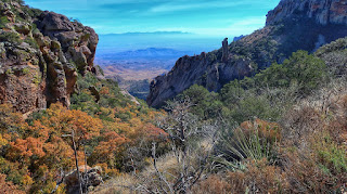
Boot Canyon and boot rock
Looking out over Boot Canyon. If you look carefully, you can see Boot Rock, which resembles a boot.


Finally, making it to the Dodson trailhead and my water cache, I found the group I chatted with at Emory. They were set up in the parking lot and were busy cooking dinner. We discussed our plans briefly, and they asked me what to expect on the Dodson while I filled up my water from the cache. I headed out again, as I’m no stranger to night hiking, and I wanted to be as close to Elephant Tusk Trail as I could get. As the sun set and it was a new moon, I quickly realized that my headlamp was acting weird and shorting out.

Sunset on the Dodson trail
The Sunsetting on the Dodson Trail

I ended up stopping early because of headlamp issues caused by high-capacity batteries. Usually, these work great and keep devices running longer (my handheld GPS), but they just didn’t play well with my headlamp. I set up camp in a hurry, made dinner, and fell asleep quickly from a hard day’s hike.


That's it for the first few days of the trip, so make sure you come back to hear the rest. Also, please let us know your favorite or ideal place for an epic backpacking trip. And if you enjoy the blog or our videos, consider checking us out on Patreon.

Supporters

Linda Pena
Ani Ruffin
Michelle Pena
Norma Morgan
Cheddar Jack


Disclaimer: This post was in no way compensated. All adventures were my own and told from my personal experiences. There are affiliate links listed on this post. If you purchase from the affiliate links, I will get a small commission. These commissions help me keep my page up to date and cover any fees on my end, allowing me to continue providing a free website for you to visit.

Comments

  1. I feel like there's so much in here I'd like to unpack with you some more. I might have to interview you.

    ReplyDelete
    Replies
    1. I'm sure there is so much more to talk about, and I'd love to be interviewed. Let's make it happen!

      Delete
  2. Hi there colleagues, its impressive paragraph about teachingand completely defined, keep it up all the time.

    ReplyDelete

Post a Comment

Popular posts from this blog

Trip Report: Sherwood Forest Faire

Tubing Down the San Marcos River