Hike Through the Chisos Mountains
Make sure you follow the adventure by checking our backcountry driving from days 1 & 2 during our trip to Big Bend National Park, and check out Day 4 and Days 5&6.
Wake Up
One of my first tasks when waking up was checking on Bmo after he was forced to sleep in his truck with only a blanket due to a leaking tent. He was alive and mostly warm, so we all jumped in my car for a few minutes with the heat on. Once we were all fully warmed up, it was time to boil water for oatmeal and Malt-O-Meal. Finally, Jack and I packed up our gear and then made our way to the Chisos Visitor Center to pick up our backcountry permit.
 |
| The trailhead at Chisos Basin |
We went in ready to implement Plan B from the day before due to the increased bear activity; however, the clerk said we were good to go on the Outer Mountain Loop (OML) if we were just passing through without camping in the Chisos Mountains. The clerk was friendly and knowledgeable, providing us with personal experiences from her own thru-hike of the OML. A few times, she drifted off on tangents when all I wanted to do was hit the trail. Once all our paperwork was completed, BMO followed us down to the trailhead, and we all covered the plan one last time before we headed out.
The Chisos Mountains
On the advice of the visitor center clerk, we left by Pinnacles towards Emory Peak. It was a chilly morning with limited visibility and tons of fog. The trail started very mild, wide like a double track, and not too steep. This was short-lived, and the trail quickly became steep, with an insane amount of switchbacks, and generally rough, rocky terrain. I believe this was Jack’s first time walking in the mountains, and he quickly learned to hate rock stairs, so we had to take frequent breaks.
 |
| Jack and I are posing for one last picture before heading out. |
It wasn’t long before we both had to take a quick stop to remove our base layers (Army silk weights), and the constant climb kept me very warm. It was unfortunate that the amazing views were obscured by the clouds, but there were plenty of other plants and animals with vibrant colors to admire. Around 3.5 miles later, we arrived at the base of Emory Peak, and thankfully, there were a few bear boxes to stash your gear before the mile-long trail.
 |
| The last climb before reaching Emory Peak |
As we were dropping our gear in one of the boxes, a guy jokingly asked where our cool stuff was stored in our bags. While clearly a joke, it still made us a little uncomfortable while we were away from all our gear. The spur to Emory Peak started out easy at first, especially considering what we had just walked, and progressively became steeper and rockier. The last portion of the trail was an almost vertical scramble up exposed rock. I climbed both rocky outcroppings. Emory Peak has the radio antennas, while Jack talked to different people just below the peak. The clouds limited our view, so there wasn’t a huge need to hang around and admire the views with so many more miles ahead of us.
 |
| The hazy view from the top of Emory Peak |
We headed back down to our gear and had a lunch of salami & cheese (a lunchtime favorite recipe), plus a candy bar, before starting off on our hike again. We were heading towards the South Rim, and the first real creature we had seen appeared. A mule deer buck (I think) was standing on the trail and holding his ground. Jack and I admired the deer and took a few pictures from a distance, and decided the buck wasn’t moving, so we started making noises, which caused him to run off.
 around Boot Springs") |
| Mule Deer (I think) around Boot Springs |
We continued on and took a short detour to Boot Spring. There was a decent amount of water, and the spring was flowing. If I were a bear, this is definitely where I’d hang out. After we explored the area and headed back to the trail, we met a volunteer. He was at the spring checking the water level and eventually asked us for our backcountry permit, which I was completely surprised by, but thankfully, I had tucked away all our documents in my back pocket.
 |
| Boot Springs was flowing. |
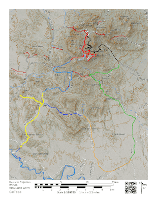
Less than half a mile down the trail, we reached the fork for the Juniper Canyon Trail and South Rim Trail. We decided to head down Juniper Trail instead of retracing our steps back up to the rims, as it was already getting late in the day. The first portion of Juniper Canyon Trail led to a huge climb up and then gravely switchbacks down into the canyon.
 |
| The view from a high point on Juniper Canyon Trail |
The views were amazing as we could look up and see the mountains and down into the canyon below. This was the first section of trail we’d been on that wasn’t well-maintained, as grass and bushes frequently grew over the myriad of switchbacks.
 |
| Looking across Juniper Canyon |
We must have taken way too long on the first 2 miles of Juniper Canyon because the sun was low in the sky. Finally, we emerged into a flat, open area parallel to the canyon, but no trailhead was in sight, and it appeared we still had a long walk ahead of us. As the day slowly gave way to twilight, it became harder to appreciate the beauty of our surroundings and focus solely on our forced march.
 |
| The view from down in Juniper Canyon |
Jack and I began creating a contingency plan for possible campsites in case it became too dark, as well as a water plan to cross-load until we could reach our cache point. Miraculously, we found the trailhead and our cached water right as the sun vanished behind a group of mountains in the distance. We took advantage of the wonderful flat ground of the parking lot to cook a hot meal and resupply our water.
 |
| The setting soon as we neared the end of Juniper Canyon Trail |
Packed up and walking again, we took our first steps on the Dodson Trail. The moon was out and bright, probably because it was just days before the Super Moon. As bright as it was, finding a possible location for our campsite was difficult, but around a half mile (that’s how far he says!) or so, we found a small area where both could squeeze our tents in. We didn't make it as far as we wanted, but it felt amazing to be lying down.
 |
| We took a quick stop at the Dodson Trailhead for dinner. |
The Bmo Saga
If you want to know how the BMO sleeping bag saga ended, there is a laundromat in Rio Grande Village. He was able to dry his bag during the day for multiple hours while he explored some shorter hikes in Big Bend. He eventually made it back to our Chisos Basin base camp around 9 pm, where he learned his bag was still pretty wet. Thank goodness the laundromat is open late, so he drove back and used a dryer until 1 am. This finally did the trick, and he was able to sleep comfortably in a dry bag after that.
 |
| Bmo at Mariscal Mines |
Make sure you stay tuned as we post the remainder of our Big Bend trip. While you are at it, go ahead and let us know your experience with Big Bend National Park. Additionally, if you enjoy the blog, follow us on Facebook to stay up to date.


 around Boot Springs")


Comments
Post a Comment