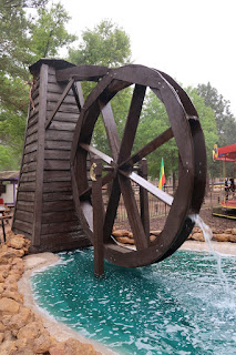
The Maiden of the Rock: A Deep Dive into Xunantunich Mayan Ruins in Belize Belize is a land rich with history and adventure, and for those who love to explore, its ancient Mayan ruins offer a glimpse into a world both magnificent and mysterious. My wife, Linda, and our friends, Eamon and Athena, and I dedicated our third day in Belize to exploring one of the most magnificent of these sites: Xunantunich, or "The Maiden of the Rock." This post will serve as your comprehensive guide to this breathtaking archaeological site, sharing our firsthand experience and helping you prepare for your own unforgettable journey. The grounds are well-kept, which we noticed the moment we walked into the central plaza, and the site is much bigger than we anticipated. The Journey Begins with a Hand-Cranked Ferry Getting to Xunantunich is a part of the adventure in itself, and it’s a detail that adds to the site's remote and timeless feel. The day of our visit was incredibly sunny, and the dri...
Angela, BeeGee, Jack and I were all able to get 2 days off at the same time and we decided we needed to take a trip somewhere. Since it has just begun cooling off in Texas and the promise of Halley’s Comet, there was a shortage of available campsites around the state. Thankfully, we found a few spots at Garner State Park.
Angela, BeeGee, and Jarrett posing on a huge rock on the Blinn River Trail
The Background
Location: 234 RR 1050, Concan, TX 78838
Admission: $8 per adult, Children under 12 are free; $15+ for campsites
We had a later start than preferred but, we hustled out to the hill country as quick as we could. Making good time, we made it with plenty of time to set up the tent, realize we forgot the water, and found a backup water container. With some daylight to spare after all that, we packed up our day packs and picked a few trails for a twilight and night hike.
Rocky terrain common across Garner State Park
Blinn River Trail
The team loaded up and we drove down to a small parking lot near the Blinn River trailhead. The Blinn trail parallels the Frio River and is only .5 miles long. I figured this trail would be nice and easy but ended up tougher than expected. The trail was narrow, rocky, and root covered.
Hiking the Blinn River Trail
Along the way, we stopped to take pictures on a large boulder and let BeeGee spend some time playing in the river. The weather was hot and muggy and splashing around in the cold water put BeeGee in a great mood. Angela hates water, so she was more than willing to be an observer and check out all the great smells at the water’s edge. We finished up the rest of the trail and ended on the Madrone Walkway.
Angela, BeeGee, and Jack posing on a huge rock on the Blinn River Trail
Madrone Walkway & Frio Canyon Trail
Madrone Walkway is a paved trail that parallels the main road through the park and is a little over half a mile long. The walkway passes a nice overlook but overall isn’t impressive; just a necessity to access other trailheads by walking. By the time we made it to the Frio Canyon Trail it was full dark.
The Madrone Trail Trailhead
The Frio Canyon Trail is almost a loop, like a big horseshoe, spends a lot of time in open fields (you can see Texas Mountains in the distance), and is 2.9 miles long. This trail turned out to be the right choice and there wasn’t anything to trip over and the stars and moon were visible. Plus, Angela is a little scared of the dark and she could see off into the distance, which helped her be less jumpy. After enjoying an easy walk and a beautiful sky, we headed back to the car and campsite, cooked a quick dinner, and piled into our 3-person tent.
Walking down the Madrone Trail just before dark
Garner State Park - Day 2
It ended up being a much warmer and more humid than expected and no sleeping bag was needed. Once all the families went to sleep everything was pretty peaceful, and just a little sticky/humid. We woke up had a breakfast of fresh eggs and salami, and readied our daypacks.
White Rock Cave Trail & Old Baldy Trail
The next morning, we decided to make the Old Baldy Trail our first stop as it is one of the highlights of the Garner State Park. When we made it to the trailhead, we saw that we found White Rock Cave Trail and decided we needed to see this cave first. White Rock Cave Trail is only .3 miles, but it has some steep elevation change and you walk up some extremely eroded areas.
The rugged trail to White Rock Cave
After some hard climbs, we made it to White Rock Cave and it was a little underwhelming. The cave may have been 10 ft. deep and looked a little gross inside. We decided it wasn’t worth climbing into the cave, so we just took a few pictures and headed back down to start our trip up Old Baldy Trail.
White Rock Cave - a quick glance in the tiny cave
Old Baldy trail is a strenuous hike at only half a mile, but there are steep climbs up water eroded trail, which means scrambling over big rocks. BeeGee loves that kind of terrain and hopped around like a mountain goat while the rest of us struggled to keep up. At the pinnacle, Old Baldy is approximately 1890 feet tall. Unfortunately, it is also a popular destination and was swarming with people, dogs, and kids.
From Mount Baldy - Overlooking the Frio River
Foshee Trail to Crystal Cave Trail
With Old Baldy conquered, we headed back down about a fifth a mile to the Foshee Trailhead. Foshee Trail is 1.7 miles and was the easiest hike that morning. Foshee Trail passes a century old rock wall shrouded in mystery and intersects many other trails in the park, which makes it an important connection trail.
Old Rock Fence - a .75 mile long rock wall on Foshee Trail
On Foshee Trail, we walked to Painted Rock Overlook and took a look back at Old Baldy. However, the sun was out in full force, so we didn’t stay long. We then linked up with Bridges Trail, which connected us to Crystal Cave Trail. Crystal Cave is the other premiere site at Garner State Park and we had to wait in a short line before we were able to head down.
Painted Rock Overlook - the view of Mount Baldy
Crystal Cave is about 30 feet deep and one small chamber. In addition, it is supposed to be cooler, but it was so humid all I wanted to do was escape. We spent a little time exploring and made our way back out to let the next group enjoy.
Campos Trail & Old Entrance Road
The next leg of our trip had us wandering around a bit lost as attempted to take Wilks Trail to Campos Trail. We ended up on Bridges Trail, Foshee Trail, Bell Trail, and Rim Trail as all these trails intersect and weave together in a small area. There wasn’t anything memorable about this section as our view was blocked and we were just waiting for our next scenic view.
CCC Horseshoe Footprint Bollards - these have been guiding hikers for over 70 years
Along the way, we passed the CCC Horseshoe Footprint Bollards and the Campos Trail overlook, but it was well into the afternoon and too hot to just stand in the open and enjoy the view. Campos Trail eventually led us to our last section of our hike, the Old Entrance Road, which was an old paved road that used to be the entrance to the park. It was a neat experience, but more importantly, it was last, easy walking, and shaded.
Campos Trail Overlook - a view across the hill country
Heading Home
After hiking for most of the day, we finished a few small tasks for breaking camp and decided it was time to eat. We headed over to the Garner grill (food trailer) and had some amazing chili cheeseburgers, which I highly rate. My one issue with the Garner Grill is the price of a drink. They only have expensive Garner State Park commemorative cups. After we had our meal, we said our goodbyes to Garner State Park and began the 3-hour drive home.
Let us know about your trips or experiences in Garner State Park. Also, if you like the blog follow us on Facebook to keep up to date.
Thanks for taking the time to read the blog! My biggest recommendation is to just get started, which is also the hardest part. I started out on a free platform, Blogspot, which is what I still use. Eventually, I paid for the domain name, but I'm still using Blogspot.
If you have any more questions, feel free to use the contact us and I'll help you in any way I can.
First Time at Sherwood Forest I have recently been introduced to the fun world of renaissance festivals, so Jack and I took a trip to the Ren Faire in McDade, Texas. Upon arrival, a group of characters were handing out flyers to gain attention for their show, which happened to be called Blunt Force Drama. Once we Jack and I finally made it through the festival gates, Blunt Force was of the first shows running. So of course, we stopped there. The show is a melee fighting tournament mixed with adult humor. The show starts by picking judges from the crowd and then the fighting begins. They even have adult humor commercials while you wait for the next round. I thoroughly enjoyed the fighting and the humor, but some might find it offensive (it was pretty racy). Also, I wouldn't take kids. Once the show finished, we followed Jack's policy of taking a lap around the grounds to see what shops and shows are available. This led me to find some awesome leather armor...
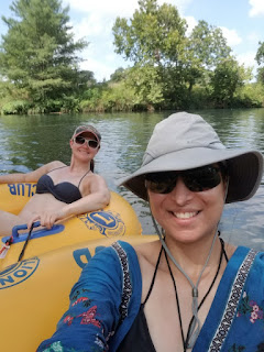
Tubing Down the San Marcos River Linda here for Adventures with BeeGee. We’ve been adventuring more aggressively since the Salkantay trek. My goal this August is to continue the adventuring while catching up on blog entries to ensure we preserve these great memories. On Saturday, July 20th, Jarrett, a friend of ours, and I went tubing down the San Marcos River. I realized I had been living in Austin for almost four years now and had not done this iconic Hill Country tourist activity. To be honest, we probably hadn't done it before because I only learned how to swim last year and am not the most comfortable in the water. The San Marcos River is relatively shallow, and the heat in Texas is unbearable, so if you want to enjoy the outdoors but are uncomfortable with water, this is a great option. The water is initially cold, but once the sun comes out, it starts feeling like a great relief from just lying on your tube. If you’re comfortable with water and swimming, I su...
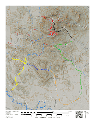
Preparing for the 100-mile Extended Mountain Loop It’s been a while, but I finally found the time to make it back out to Big Bend National Park. If you are interested in our first trip to Big Bend, you can follow along here: Big Bend 2015 . I headed out for the trip around 2 pm on December 2, 2018, for what I’ve termed the Extended Outer Mountain Loop, a 100-mile backpacking trip spanning 7 days. The plan was to meet up with my dad, Bmo, in the Chisos Mountains, cache water, and then start the adventure. Planned 7-day route for Big Bend National Park Big Bend National Park Background Location: 310, Alsate Dr, Big Bend National Park, TX 79834 Admission: $25 per vehicle, $14 campsites, $12 backcountry pass Elevation: 1,800 to 7,832 ft. Weather: Varied from rainy, cloudy, and sunny, 30 to 65°F Difficulty: Strenuous Website: https://www.nps.gov/bibe/index.htm 7 days' worth of food The Drive Out I didn't get to leave as early as I would have liked ...


Thanks for taking the time to read the blog! My biggest recommendation is to just get started, which is also the hardest part. I started out on a free platform, Blogspot, which is what I still use. Eventually, I paid for the domain name, but I'm still using Blogspot.
ReplyDeleteIf you have any more questions, feel free to use the contact us and I'll help you in any way I can.
Hi there! I just want to give you a big thumbs up for the excellent info
ReplyDeleteyou have got here on this post. I am coming
back to your site for more soon.
Thanks for taking the time to read and I hope you do come back for more.
ReplyDelete