Texas Regions
The Many Regions of Texas
Texas, being a large state has a variety of regions to visit
and explore. Each region will be
beautiful in its own way and will present its own issues that will need to be
overcome to adventure there. I will
cover the different regions using the Omernik level III ecoregions. This system was developed in 1987 by (you
guessed it) Omernik. The system has been
adopted by the EPA and other governmental Agencies.
 |
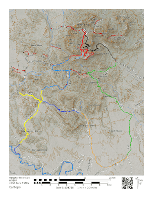
| The Regions and Counties of Texas |
Arizona/New Mexico Mountains
The Arizona/New Mexico Mountain Region barely enters Texas,
but it is present nonetheless. These
mountains have lower elevation than surrounding mountains and have vegetation
present from drier climates. The Guadalupe
Mountains National Park is found in this region.
Central Great Plains
This region is slightly lower in elevation than the
neighboring high plains. In addition, it
receives a little more rain as well. The
region is mostly croplands now, but was once grasslands with scattered trees
and shrubs. Lake Arrowhead State Park is
found in this region, which contains a lake and a few hiking trails.
Chihuahuan Deserts
This region is the
southernmost desert in the United States and extends approximately 500 miles
into Mexico. The vegetation here is
mainly desert grassland and shrubland; however, at higher elevation oak, pine,
and juniper can be found. Big Bend
National Park can be found in this region, which is one of my favorite parks.
Cross Timbers
This region extends
from the hills of Oklahoma. The natural
vegetation is old growth oak and cedar trees.
In addition, the region is mostly comprised of rangelands and pastures. Possum Kingdom State Park is found in this
region, which contains a large lake.
East Central Texas Plains
The central plains
have clay soil and are irregular plains.
In addition, the vegetation is that of open prairie with much of the
region used as rangelands and pasture.
This region has Bastrop State Park, which has scenic hikes and bike
rides through the pines. In addition, I
went to the Boy Scout camp Lost Pines many times as a child, which is very
close to the Bastrop State Park.
Edwards Plateau
This region is known
to be hiller than other areas in Texas.
In addition, it is a limestone plateau and distinguished from
neighboring regions by a fault line.
Furthermore, the region contains a network of creeks. Finally, the region is used for grazing
cattle and other herd animals. Lost
Maples State Park is in the region, which has beautiful leaves during
autumn.
High Plains
This region is
higher and drier than the neighboring central plains. In addition, this region is smooth plains
with a large portion used for crops.
Furthermore, the region has a variety of native grasses. Palo Alto State park is in this region, which
contains the United States Second largest canyon (second to the Grand Canyon).
South Central Plains
This region is in
east Texas and has a significant amount of pines and other coniferous
trees. Locally, the area is known as
“piney woods”. The region contains very little cropland, but is a site for
lumber. This region contains Texas’s
longest continuing hiking trail, The Lone Star Hiking Trail at 129 miles.
Southern Texas Plains
This region has
rolling hills and extends into Mexico.
The area was once grasslands, but has slowly been taken over by the
mesquite tree. The area is known locally
as “brushlands”. The region is dry but
has unique plants and animals worth checking out. The Kickapoo Cavern State Park is found in
this region and has a variety of activities: hiking, camping, biking, and
caving.
Southwestern Tablelands
The Southwestern
Tablelands contain canyons, mesas, and badlands, which are separated by
rivers. The area has very little cropland
as it is semiarid, and contains vegetation similar to other semiarid regions in
Texas. The Caprock Canyons State Park & Trailway is found in this
region. This park is another that has a
variety of activities including hiking, biking, and a new herd of bison.
Texas Blackland Prairies
The Texas Blackland
Prairies are nearly level and have a mix of grasses. In addition, this region has a higher
proportion of croplands than neighboring regions. Furthermore, the region is being converted to
urban and industrial uses. Bonham State
Park is found in this region, which contains a small lake and a variety of
outdoor activities.
Western Gulf Coastal Plains
This region is flat,
humid, and mainly grasslands. However,
the further inland in you travel, the more hills and forest are found. Furthermore, this region provides access to
the Gulf of Mexico. This region is also
being urbanized quickly. The Matagorda
Island Wildlife Management Area is found in this region. This park is also, where I am planning my
next multiday adventure. The island is
secluded and is a great location to backpack and mountain bike.
Comments
Post a Comment